| ILLINOIS DOT | IL STATE TOLL HIGHWAY | CARMA | TRIVIA | LINKS | TRAILS | COUNTIES | WHO AM I? |
| This
site is owned, written and copyrighted by Rich Carlson. I have no connection
to IDOT, ITHA or AASHTO.
Business US Routes in Illinois
The Chicago Area Radio Monitoring Association is the Largest Scanner Club in the USA. See why here!

|

 Want
to talk about Roads and Roadtrips? Do it here!
Want
to talk about Roads and Roadtrips? Do it here! All
about the Tollways in Illinois
All
about the Tollways in Illinois Illinois
Department of Transportation's Web Site. (The Offical State Highways
Site!)
Illinois
Department of Transportation's Web Site. (The Offical State Highways
Site!)|
A comprehensive look at the history and evolution of the Illinois Numbered Highway System.
|
|||
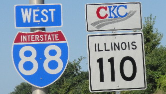
New (August 2010): Chicago-Kansas City Expressway Designation!
Read about the "CKC IL-110" markers on the I-88 EW Tollway!
Ever wonder why the road in your town is numbered what it is? Whatever happened to Route 66 (or 42 or 116A...) Why is I-94 posted as East-West When it runs North-South? What's the difference between a US Route, an Interstate and a State Route? How come the road out there has 2 different numbers on it? If you ever asked questions like these, read on and get the answers.
Illinois was an early leader in providing a numbered highway system. First authorized in 1918 only Wisconsin preceded Illinois, and only by a few months. Michigan followed soon thereafter. It wasn't until 1926 that a nationwide system was established. In the first 20-25 years of the 20th Century several "Auto Routes" or “Trails” had been marked by private auto and bicycle clubs as well as civic organizations but these were inefficient, routed to and thru the towns or businesses that paid to be included on the route.
In 1918 the state legislature let a series of bonds that paid for individual highways between city pairs. While some of the roads already existed in part this was the first time that an organized system of roads was built in Illinois. The 1918 "State Bond Issue" roads (SBI 1 thru 46) were laid out in somewhat of a regional pattern. SBI 1, 2 and 3 were N-S roads that ran pretty much the length of the state, 4 was a diagonal road from Chicago to St. Louis, and Routes 5 thru 20 were E-W roads thru out the state. The rest (21-46) were mostly connector or regional roads of importance. Later, in 1924, another set of bonds was issued, from 47 thru 185. These were used for fill-in routes, connectors and roads to satisfy local politicians to ensure that every community was well served. As the bonds were let and purchased the roads were built and the State Bond Issue number was used to designate the road. The first Illinois Route Marker was a simple outline of the state with the 1 or 2-digit number inside. There were also a batch of lettered routes, mostly “A” but a couple “B”’s and “C”’s and one set of “N” and “S” roads. These letters were added to the marker below the number. These letter appended routes were spurs from the main road, the N-S roads were on opposite sides of a local river. Soon it became necessary to reroute roads, change numbers and add new ones. While the SBI numbers remained the backbone of the route numbering system there were enough changes where there became two systems. The SBI numbers were retained as an inventory of roads originally financed from them and the State highway numbering system, while retaining many of the SBI numbers, evolved, grew and eventually retracted.
It took the Feds a few years to get into the act. By 1926 many states had their own systems and occasionally state numbers crossed over the border and were retained by the next state. Most of the time however a route that crossed state lines usually changed numbers as it did. The state highway departments as well as the US Department of Transportation (then called the Federal Highway Administration) cooperated on a common numbering system that we now know as US Highways. Back then it was referred to as Interstate highways, not to be confused with the modern day Interstate Highway System. The US Route System is not a federally built, financed or controlled system, it is merely a common numbering system for specific state highways.
Since Illinois and other Midwest states already had an excellent (for the times) paved road system most US route numbers were just applied to existing State highways as additions to the existing state number. Some of the numbers were changed before they were posted, most notably being US-66. Originally set to be US-60, it was changed before being posted but not before many maps were printed. In Illinois several of the new US Routes were posted. US-66 replaced for the most part IL-4 from Chicago to St. Louis, US-40 replaced IL-11, US-30 replaced IL-6 and so on. Mainline US Routes in Illinois were US-6, 12, 14, 20, 24, 30, 32 (replaced mostly by 34), 36, 40, 41, 45, 50, 51, 52, 54, 60, 62 (60 and 62 were and are only in IL for a matter of blocks), 66 and 67. There were several 3-digit US routes, most of which did not survive the 1930s. Illinois probably had more 2-digit US routes than any other state with 21. While US-66 is gone and a couple have been contracted (most notably US-54) the rest remain pretty much where they were.
In the 1950's the Interstates were being planned. Now known as the Eisenhower Interstate System, Illinois was a nexus for these new super-highways. While there was already several controlled access roads around the state, including parts of the Illinois Tollway system, most of the Interstates were newly built. They for the most part replaced US highways, I-55 replaced US-66, I-94 replaced US-41, I-70 replaced US-40 etc. Except for US-66 the US route usually remained on the old road but most of the traffic moved to the new facilities. After the Interstate system was nominally complete in the early 1970's the state cleaned up the route systems and shortened many numbered routes, both US and State. This "Great Purge" got rid of irrelevant numbers by shortening the numbered routes or dropping some numbers altogether. The state route numbers and their history played a big part in the regulated trucking industry. Before it was deregulated in the 1970’s and 80’s companies were given the right to serve specific areas and use specific roads to get there. The route they served would not change if the highway’s number did, so they had to know what roads existed where to maintain their compliance. The Central Motor Freight Association maintained an extensive list of the routes in Illinois to assist their members in abiding by their regulated routes. Unlike Wisconsin, Illinois did not have a coordinated County road system. While many counties use the National Association of Counties (NACo) pentagram marked and numbering system this is a more recent development of the last 20 years. In the larger metro areas county roads usually are named and fairly indistinguishable from local roads. In rural areas many county roads are named on geographic terms, with numbers such as 200N or 450E. These indicate hundredths of a mile from the county line in the direction noted. CR 200N would be an E-W road about 2 miles north of the county line and CR 450E would be a N-S road 45 miles east of the county line. Obviously most of these numbers would change from county to county. The NACo system uses letters and numbers, with the lowest designators being in the far NE corner of the state (for E-W roads) and the SW corner of the state (for N-S roads). Lake County for example has route 1A, as could any other county on the far north edge of the state. Some counties that use the blue pentagram marker do not use the NACo numbering system and instead uses whatever numbers they elect to.
Did you find an error on my site? Want more information?
Rexie's cute little Corner of the Web (Art's & Crafts etc.) My wife has a life and a web site too. See What she does with it. LMCT marker courtesy Christopher Bessert, used by permission Updated: 4-17-2018 |